
9 Map Reading Tips for Modern Adventure Dads
9 Essential Map Reading Tips for Adventure Dads
Lost? Yep, I’ve been there. Liam on my back, Sarah ready to unleash the eye roll of doom. Here’s how I turned it around: I learned topo symbols, traced contours like a pro, and traded that gas station compass for a trusty one. GPS glitches? I carry paper maps now.
I write for Modern Dads because, let’s face it, navigating parenting—and the great outdoors—can feel like a treasure hunt. Remember when upgrading to a Garmin eTrex turned my hiking game upside down? Now, even Emily leaves me in the dust at trail junctions.
Not too long ago, I took a wrong turn while hiking. The kids and I ended up in a wildflower meadow instead of our usual spot. We laughed, played, and learned a bunch about taking risks. Sometimes, the detours are the best part.
Quick Takeaways
- Master topographic map symbols and scales to accurately interpret terrain and distances.
- Use contour lines to identify elevation changes, with tight lines indicating steep slopes.
- Always account for magnetic declination when using a compass with your map.
- Carry a paper map and compass as backups when relying on digital navigation tools.
- Practice matching terrain features like ridges and valleys to map details for better orientation.
Learn Topo Map Symbols First
Don’t be me. Check symbols. Save dignity. Pack carabiner coffee mugs to keep your beverages secure while navigating challenging terrain.
Measure Distance Using The Scale
Most USGS maps use a scale like 1:24,000, which means 1 inch on the map equals 24,000 inches in reality—roughly 0.38 miles. Yeah, I stared at that for five minutes too while Liam giggled.
Use a ruler or the edge of a paper, mark your start and end points, then compare to the map’s scale bar. Works way faster than yelling, “Is that lake *still* far?” like I once did.
Sure, your Digital GPS might claim it knows best, and sure, Satellite imagery looks cool, Sarah’s phone even shows cute little animated trees—but nothing beats knowing how far you’ll *actually* hike. Especially when your kids say, “Are we *there* yet?” three miles in. Consider bringing a pocket magnifying glass along to read smaller map details more clearly on the trail.
Read Contour Lines: Find Hills And Valleys
The contour interval (check the map legend, genius) tells you how much elevation changes. On a 40-foot interval, tight lines mean you’re climbing like Liam after candy. Wide apart? That’s Sarah-level laziness—flat and chill.
Use hillshade visualization (fancy talk for “3D-ish shadows”) to spot valleys easier than finding socks in our laundry black hole.
See a “V” pointing uphill? That’s a stream, not a typo.
Staying hydrated on the trail is just as important as reading your map, so pack collapsible water bottles to keep your kids refreshed during long hikes.
Want to avoid becoming a sweaty dad-statistic? Read the lines. Trust me—my knees still ache from Black Mountain.
Locate Yourself With A Compass
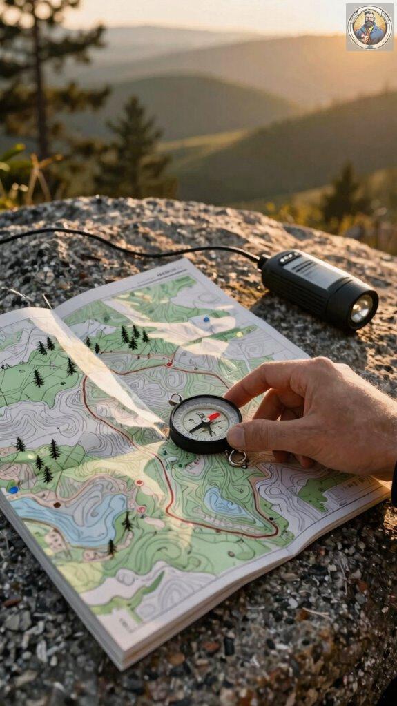
That’s where your buddy, the compass, struts in. Lost again, Dad? Yep, me too—especially when Liam swore we were “totally close” to the waterfall. Spoiler: we weren’t.
First, check magnetic declination—it’s not sci-fi, just the map-vs-complaint gap between true north and what your compass dreams of. Ignore it? Congrats, you’ve joined Team Lost.
Most apps now offer digital compass integration (looking at you, Gaia GPS), which means your phone won’t just die dramatically mid-hike. Consider pairing a rechargeable headlamp with your phone so you can navigate safely after sunset without draining your battery on flashlight mode.
Pair it with a Suunto MC-2—tough enough for Sarah’s “quick” forest detours.
Want real fun? Try triangulating with two landmarks. Or just admit you need help. I do. Often.
Orient The Map Using The North Arrow
– First, lay your map flat—on a rock, a log, your pride after getting lost twice in one weekend, whatever works.
Now, line up the north arrow with true north using your compass—because unless you’re a magnet, you shouldn’t wing it.
- Match the map’s north arrow to compass north—no guesswork, unless you enjoy explaining *digital map integration* to a squirrel.
- Check terrain features—that hill to your left? Yep, it should match *satellite imagery matching* apps (looking at you, Gaia GPS).
- Rotate the whole map, not your ego, until landmarks snap into place.
Works better than Wi-Fi when Liam says, “Dad, we’re *definitely* lost.” Again.
Plan And Mark Your Route
- Start point? Check.
- Water crossings? Mark ’em.
- Emergency bail-out? Yeah, like that sketchy trail near Bear Potty (real name, seriously).
Trust me: 10 minutes now beats crying later.
Marker placement wins arguments. Always.
Just as characters in teenage isolation narratives must navigate emotional terrain, modern adventure dads need to map physical routes with equal care and attention.
Match Terrain: Identify Landmarks On The Map
I slap the map down and play detective—”Where the heck are we?” Terrain matching turns clueless into confident.
Seriously, even my eight-year-old Liam can spot a hill that looks like a squashed burrito.
- Find three landmarks: A trail junction, that lopsided boulder, and Peak #4 (dubbed “Mount Dad’s Lost Phone”).
- Match contour clues: If the squiggles cluster tight—yep, that’s a cliff. Not a suggestion.
- Verify with pace and compass: Landmark identification isn’t magic—it’s science with sass.
When teaching kids map skills, remember that Leave No Trace principles ensure they learn to navigate responsibly while protecting the environment.
Last weekend, Sarah laughed when I mistook a cow pasture for a lake. Again.
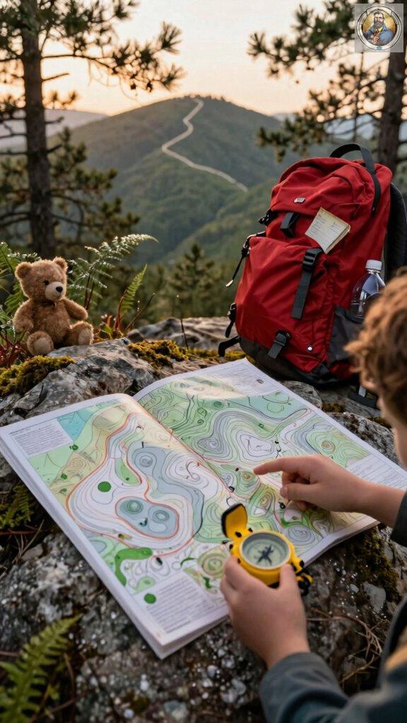
Practice Navigation With Orienteering Games
While you’re still thinking GPS is the only way to find a trail, I’m out there teaching my kids how to navigate like mini survivalists—with nothing but a map, compass, and a sense of adventure.
Forget “Where’s Waldo?” Try “Where’s Liam?” with a twist: real bushes, fake bandits, and Emily racing ahead with a Suunto compass. We play orienteering games in state parks—no GPS integration allowed (though I once caught Sarah cheating with her AllTrails app).
Use digital mapping tools *after* they find the control point. Since we’re spending hours outdoors practicing navigation, staying hydrated is critical—having access to personal water filters ensures the kids can safely drink from natural water sources along the trail.
Humor? One kid plotted a “shortcut” into a pond.
Pro tip: Make it a scavenger race. Loser carries the tent. Win-win.
Always Carry A Paper Map Backup
You think your phone’s got you covered until it doesn’t—like when Liam dropped his in a creek and screamed like he’d lost a limb.
Digital mapping? Great… until your battery dies. GPS integration? Cool, but not infallible. That’s why I *never* hit the trail without a paper map backup.
Seriously, it’s not paranoia—it’s parenting.
Here’s why you need one:
- Paper maps don’t need charging, updates, or Wi-Fi (unlike someone’s *favorite* app).
- They won’t crash mid-hike when you’re arguing with your GPS.
- They’re backup heroes when digital mapping fails—again.
Consider pairing map navigation skills with family fitness games to keep everyone engaged during outdoor adventures. Stay smart. Stay found. And maybe don’t let the kids near rivers with phones.
Teaching Compass to Son
With Emily, we started simple:
- Point the red needle this way, not that way, buddy.
- Nope, the compass isn’t broken—your sense of direction is.
Teaching navigational skills? It’s like teaching sarcasm—takes trial, error, and a few eye rolls. We practiced in the backyard.
“Liam, north isn’t toward the snack drawer.”
Safety planning means knowing which way to run when bears crash your picnic. Or when Emily “accidentally” leads us into a thorn bush.
Spoiler: She didn’t.
Pro tip: Buy a Suunto A-10. Drop-proof. Kid-proof. Mostly.
Now Liam can find north blindfolded. Almost.
For evening navigation practice, consider equipping your child with rechargeable headlamps so they can safely learn directional skills after dark.
Purchase Orienteering Gear Today
If you’re still fumbling with a gas station compass while your kid tries to navigate using Minecraft instincts, it’s time to upgrade—seriously. I learned after getting us lost near Mammoth Lakes—thanks, “intuitive” paper map and zero signal—your gear matters. When selecting orienteering equipment, remember that proper daypack sizing ensures your child can comfortably carry navigation tools and supplies on longer expeditions.
- Pick a GPS device selection that won’t quit in the woods (Garmin eTrex is my go-to).
- Master digital map apps *before* you need them—offline mode saves sanity.
- Pack a real compass. Yes, *still*. Liam thought his smartwatch counted. It didn’t.
Sarah still laughs at that “shortcut.” Don’t be me. Gear up.
FAQ
Can I Use My Smartphone Instead of a Paper Map?
Yeah, you *can* use your smartphone—Digital navigation rocks… until your battery dies. I learned that when Liam yelled, “Dad, we’re lost… again?”
GPS reliability? Great… if you’ve got signal. But out past mile 8 on the PCT? Forget it. Save power. Download offline maps. Bring a paper backup.
Trust me. Your kids won’t care about your tech skills when they’re hungry, mad, and naming squirrels. Plan ahead. Stay charged. Stay sane.
How Often Should I Replace My Compass?
I replace my compass only when it flatlines—like my last one did after Liam dropped it in a creek. Honestly? They’re tough, but check compass calibration yearly.
If north’s playing hide-and-seek, it’s time to upgrade.
Use Suunto or Silva—they don’t ghost you mid-hike.
Pair it with solid map navigation techniques, and you’re golden.
Ever trusted a wobbly needle? Yeah, don’t.
Are There Apps That Read Topo Maps Offline?
Yep, totally! Topo map apps like Gaia GPS and Avenza slap topo maps right on your phone—offline. No cell signal? No problem.
I downloaded a trail near Lake Liam last trip and crushed it. Digital navigation’s my co-pilot now. Just don’t let your phone die.
Pro tip: stash it in Emily’s old waterproof case. Sarah says I’m paranoid. Maybe. But I’m *prepared* paranoid.
What Clothing Should I Wear for Map Reading?
I wear weather resistant clothing like a trusty Patagonia rain shell—because getting soggy while reading a map? Not the adventure I signed up for.
Layered apparel? Yes, please.
I start with moisture-wicking base layers (thanks, Smartwool), add a puffy mid, and top it off just right—like a burrito of warmth.
You think clouds look innocent? Wait till they dump rain on your topo map.
Been there, shivered through it, scared Emily with my dramatic chattering.
So listen: bring gloves that work with touchscreen tech—because no, you shouldn’t peel off mittens with your teeth like I once did (Liam still teases me).
Pack a beanie. Hats are low-key heroes.
And wear sturdy boots—your feet aren’t sacrifice zones.
Stay dry. Stay sharp. Your map won’t read itself.
Do I Need a License to Carry a Compass?
Nope, no license needed to carry a compass—unless you’re accidentally summoning pirates with it.
I tucked a Suunto MC-2 into my pocket last summer, compass calibration done, and bam—map orientation made me look *way* smarter than I felt.
Truth? Liam still thinks north is “where the snacks are.”
Pro tip:
- Calibrate away from metal
- Check declination
- Pretend you’re Bear Grylls (but maybe skip the bug-eating part).


